Day 1 - BondCliff to Guyot Campsite
Our trip actually started the on July 4th at the Franconia Brook tentsite just outside of Lincoln Woods trailhead. The idea was to camp and get an early jump on hiking in the morning.


There were 24 tentsites, so finding one was not a problem. There is a forest ranger that checks in with you in the evening, but it is just to say hi and make sure all is well. There was no cost to stay here. He even ofter to filter our water for us should we have needed that. We ended up grabbing site #2 which was pretty close to the river and had a decent number of trees to hang a tarp. (Most of the sites have many trees over there.) It is certainly possible that there are better tentsites than the one that we picked, but we had to decide on our quickly due to the on coming rain just minutes away.
 |
| Here's our new tarptent all zipped up from the rain...We didn't have fireworks for the 4th of July, but we certainly had a show of thunder and lightening that night! |
 |
| The backside of our Franconia Brook tentsite; just on the other side lies the East Branch of the Pemigewasset River |


We used the little blue tarp to cook our dinner that night while protected from the rain. Good thing that we decided to bring this tarp at the last minute. We had one of my favorites: Mac & cheese with tuna and Mrs. Renfro's hot salsa. We had hoped to build a fire that night (since once you get above treeline, fires are prohibited), but even though the rain had stopped there was nothing but little kindling sticks that had dry enough to burn.
Compared to the last trip (to the Manistee River), we had significantly reduced the base weights of our packs. The target was that the lower weight would be enough to keep us moving on our feet and able to cover more miles (especially) considering much of the trip is vertical too! We are be no means UL, but have made some serious strides to removing unnecessary luxuries that aren't multi-purpose. I can thank Mike to pushing me to do this :)

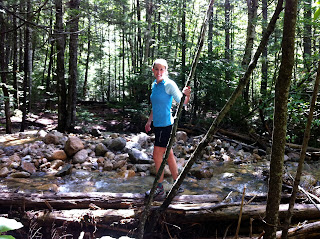
In order to get on the trail we planning to first to head up, we had to cross the branch Pemigewasset River. This was my first water crossing. Although the river didn't get that deep (just under my waist), I was still glad to have trekking poles. This made the feat easy - except for being alittle cold. Here's a picture of Mike after he crossed over the Pemigewasset River. You can't see them, but he's waving his neon yellow trekking poles.

Detour: Starting the PEMI loop counterclockwise
Originally, we were planning to start the PEMI loop on Osseo Trail, which links up from Lincoln Woods Trail. Unfortunately, after the water crossing, we ended up on Lincoln Brook Trail (note the close name.) While it would have been nice to see 13 Falls (that is where Lincoln Brook Trail was eventually head), we wanted to get out to the ridgeline. We had to retrace our steps, but were now actually much closer to Bondcliff trail, than Osseo Trail. We made the executive decision to hike the PEMI loop CCW instead of CW. We were now headed up to the alpine zone in the Bondcliff.
Bondcliff trail starts out flat and is actually an old logging railroad. You can see the all old the railroad ties and this trail is exceptionally straight. Now that this region is designated wilderness, nature has taken back over, but the trail still gets to take advantage of the line already created from those logging days - kinda neat!
Bondcliff Trail is flat for a while, but then starts heading up the side of the bonds quickly...if you are looking for many switch-backs, don't bother, this trail is mostly hiking straight up the small rocks and mini-boulders. This does help you get to your destination faster. The other nice thing about this trail is the frequent water sources, one spot was where we stopped to eat a quick snack/lunch. This made getting water for our later climb very convenient.


Bondcliff
 We had it to Bondcliff just after lunch time, and had a little snack at the top. It felt good to just sit and relax for a bit. Bondcliff is a vast open spot; there is a great sense of having the summit to yourself (even if you really don't.) We took some pictures of Franconia Ridge from Bondcliff - that's where we would be headed on the 3rd day of our trip. We also took our pictures on the popular Bondcliff ledge. That's Mike in yellow and me in the red.

Mount Bond
The Bondcliff Trail continues up to Mount Bond. The clouds were in really low here so we don't have great pictures, but we did run into a group of dayhikers that gladly snapped a photo for us. This was the last summit before Guyot campsite. There is a 0.5 mile off shoot from the Bondcliff trail where you can go to West Bond for the sunset. During our time there, I am not sure how well things cleared up for a good view that night. (We didn't summit West Bond.) On a clear night, I hear that this is a very nice view though.

Night 2: Guyot Campsite
Guyot campsite was our second night destination. The topo map made it look like this campsite was going to be up higher than it was. At the end of this 1st day, it just seemed we headed down and down to get to the campsite. The campsite is run by the AMC, so for 2 people it was $16. All the small platforms were taken, so we had to use a group one. We ended up sharing with a girl and guy who had been at the greenleaf hut last night - stuck in the storm. The were also doing the PEMI loop, but this was the last night of their hike. They were heading just down Bondcliff tomorrow.
It took alittle extra time to set up the Tarptent on the platform since it is not a free standing tent. However, with the tiedowns provided (hooks on the side of the platform) and the rocks to hold down the other lies, the tent stood just as it normally would. It was impressed by the versatility of this tent, since stability had been my hesitation upon getting it. Random comment: It is probably not likely that these "large group" platforms could easily hold more than 2 tents...so I am not sure why they just don't call them double platforms instead of "group" ones.
Guyot campsite had a designated cooking/cleaning area and nice spring to get water. The people there were all friendly and several chatted about where they had hiked for the day. It was really cool to realize how many different trails and options there really are out here. Everyone was just doing their own thing.
 |
| Mike after setting up the tent at Guyot Campsite |
Day 2 - Twinway to Garfield Trail
The second day began with hiking to the top of Mount Guyot (very close to the campsite.) Then came an easy traverse for a bit before heading up to South Twin. Coming down South Twin was probably one of the most technical parts of the trip, and where I had to learn to use my trekking poles better. Part of the decent from South Twin brings you near the Galehead Hut. This is where we stopped for a short break along with several other hikers. This AMC hut was so much nicer than I had expected!! (built in the last few years) They were serving some blueberry coffee cake and some other homemade bars. Mike tried the coffee cake and said it was very tasty.
From Galehead hut, we continued down South Twin until the trail finally starts heading up again on Mount Garfield. Between the down and up here, there was significant vertical put in this 2nd day. We had heard that the climb up Garfield was very difficult, but we didn't find it to be much worse than some of the other short stretches of bouldering we had to do earlier. Halfway up Mount Garfield is the entrance to the campsite. There is a little spring-brook right at the trail, which was the water source for the campsite. This is alittle hike down from the actual platforms once you get up there. Fortunately, one of the other hikers from Galehad had mentioned to fill up water here before heading to the campsite - unless you don't mind coming back down the steep path for water again.
 |
| Top of Mount Guyot. This was taken by a group of 4 guys all we packs that looked to be packed with a ton of stuff - just for 3 days |
 |
| Views from the Top of South Twin |
 |
| View of parts of the Presidental Range from South Twin |

 |
| I love this picture. It captures the essence of all the different types of hikers out at Galehead Hut. |
 | |
| Here's an example of the trail on the South Twin decent. |
Night 3 - Garfield Campsite
We spent our last night at Garfield Campsite. Again we had platform camping because there aren't really any flat spots on the side of the mountain. This time we had our own platform, but were right next to a couple doing all 48 summits in the White Mountains (not all at once), and a AT through Hiker. The through hiker was pretty chatty and it was interesting to hear about what the experience is really like. For example, I didn't know that most of those people take "zero" days where the just catch up on rest and other things in town; therefore, there are some days these guys don't coverage any mileage. He was explaining how its really easy to do 15-20 miles per day on certain parts of the AT.
 | |
| Tarptent on the platform again. We had a great pitch for the second night on the platform. Good thing...it was really windy up on Mount Garfield that night. |
Day 3 - Garfield to Lincoln Woods
The 3rd day of the trip was by far and away our most difficult day...mainly because of the mileage and vertical we had to cover to reach back to Lincoln Woods. Our third day trip was Mount Garfield > Mount Lafayette > Little Haystack > Mount Lincoln > Mount Liberty > Mount Flume > Osseo Train > Lincoln woods. Most of these summits were along the Franconia Ridge, but it still didn't take away the vertical up and down between summit to summit. We ended up leaving camp at 6:30 am to be sure to allow ourselves plenty of time to get back to the car before dark. This first picture is the trail to Mount Lafayette. Look closely, you can see some hikers near the top! (That would be us soon...)

 |
| Trailhead at the top of Mount Lafayette. We had great views here. |


Franconia Ridge offers some of the best views...but it also gives an intimidating look at what is yet to come. The best feeling came at the end when Mike reminded to reflect back to seeing Mount Liberty, Mount Flume, and the decent of Osseo trail far, far off in the distance and how I thought we had so far to go. Sure enough, (even with out feet hurting some) we descended down the 4.4 miles of Osseo train much faster than I thought...and definitely in time for a hearty dinner!

Click here for Full picture album.

 |
| At the top of Mount Liberty...only Mount Flume remained yet to summit |
 |
| Mmmm...our dinner after the loop |
No comments:
Post a Comment